Annapurna Circuit Trek at a Glance
| Highest point | Thorong La, 5,416M / 17,769FT |
| Duration | 10 days from Kathmandu, 6 of them walked |
| Walking distance | 65.6KM, Chame to Muktinath |
| Highest night | Thorung High Camp, 4,880M |
| Direction | Anticlockwise: Besisahar to Muktinath and Jomsom |
| Grade | Challenging, not technical |
| Permits | ACAP (NPR 3,000) and TIMS card (NPR 2,000) |
| Guide | Licensed guide required since 31 March 2023 |
| Best months | October, November, March, April, May |
| Our price | USD 599 to 790 per person, by group size |
The Annapurna Circuit is not the Annapurna Sanctuary trek. The Sanctuary is the basin around Annapurna Base Camp, on the south side of the range. The Circuit goes round the north side, behind the mountains, through Manang and over Thorong La.
Is the Annapurna Circuit Open in 2026?
Yes. ACAP listed Thorong La as open on 6 October 2026, after a closure at the end of September, and said on 7 October that every Annapurna route was open except Nar Phu. Nar Phu reopened on 15 October. On 7 October ACAP still listed Chame to Bhratang as walking only, with vehicles running from Bhratang to upper Manang.
Conditions on the Circuit change after every big storm, on the pass and on the roads at both ends. We keep a dated record of ACAP and TAAN notices on our Annapurna Circuit trail news page. Read it the week you fly, and talk to us if you hold a departure.
Annapurna Circuit Map and Route
The route runs anticlockwise round the north side of the Annapurna range: up the Marsyangdi valley from Besisahar through Chame, Pisang and Manang, over Thorong La, then down to Muktinath and the Kali Gandaki at Jomsom.
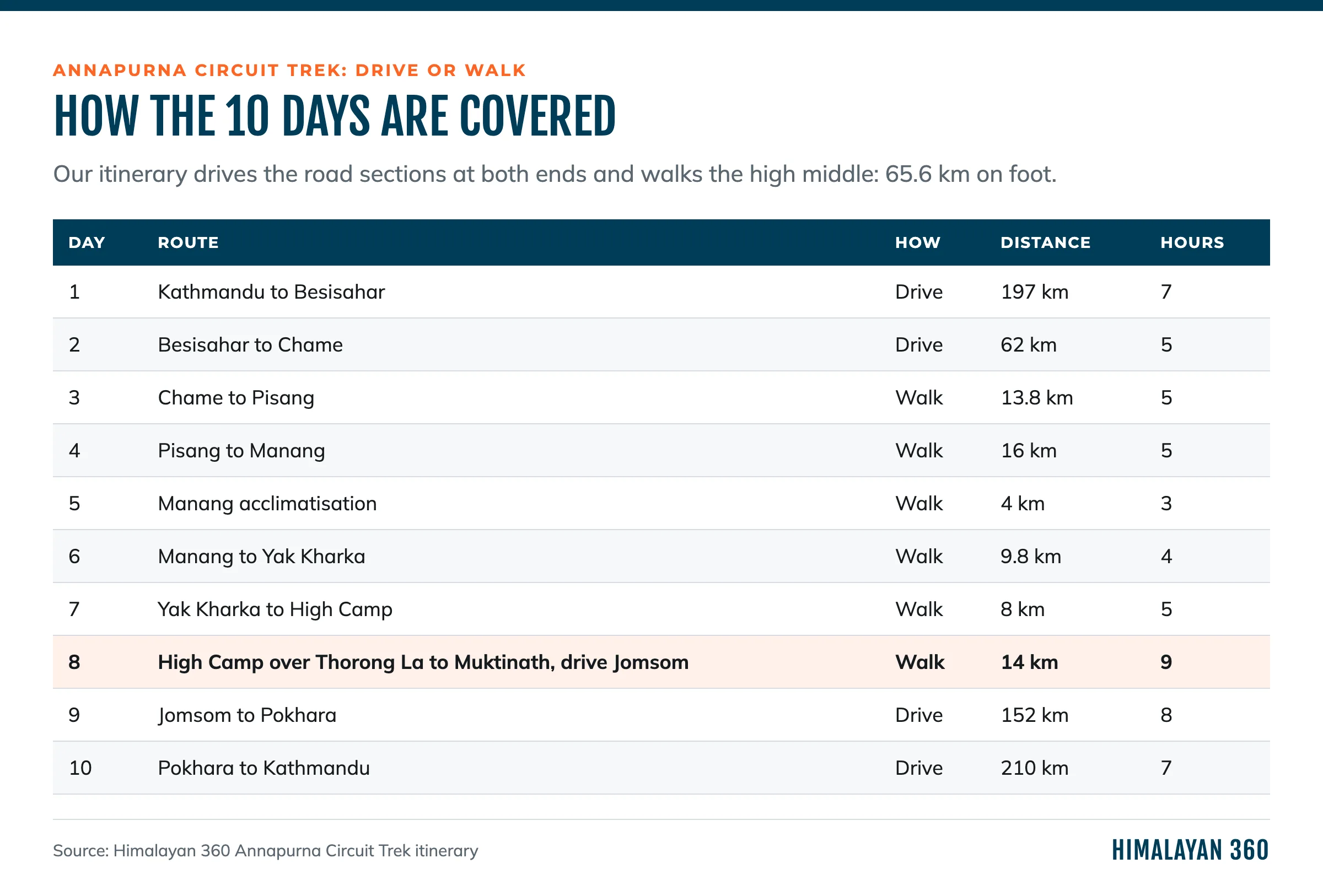
Which days of our itinerary are driven and which are walked.
Where Does the Annapurna Circuit Start?
At Besisahar, 197KM and about 7 hours by road from Kathmandu. Most itineraries now carry on by jeep up the Marsyangdi road. Ours drives to Chame (2,650M) on Day 2 and starts walking there. If you have done the Manaslu Circuit, you already know the lower Marsyangdi: the Manaslu trail comes out at Dharapani, on this road.
Why Anticlockwise?
Because the climb to Thorong La is far gentler from the Manang side. Going anticlockwise you approach the pass over several days, sleeping at Manang, Yak Kharka and High Camp. The other way, the climb from Muktinath to the pass is the 1,747M you would otherwise descend, in one day, with little chance to acclimatise. Almost every itinerary goes anticlockwise for that reason.
How Long Is the Annapurna Circuit?
Our itinerary is 10 days from Kathmandu to Kathmandu, with 6 walking days and 65.6KM on foot. That is the high middle of the Circuit, from Chame to Muktinath. Everything below Chame on the east side and below Muktinath on the west is driven.
Longer itineraries walk more of the valley floor. A 12 to 14-day version usually starts walking lower in the Marsyangdi and adds a night at Ledar or Thorong Phedi. Versions of 15 days or more add the Tilicho Lake detour, or walk down the Kali Gandaki to Tatopani and on to Ghorepani and Poon Hill. Published distances for the "full" Circuit vary a lot, because each operator measures a different mix of trail and road.
Can You Really Do the Annapurna Circuit in 10 Days?
Yes, by driving both ends. Ten days is enough to walk the part people come for, the high valley and the pass, with one acclimatisation day in Manang. What you give up is the lower Marsyangdi on foot, which now shares its valley with the road, and the walk down the Kali Gandaki. What you must not give up is the Manang rest day.
Annapurna Circuit Itinerary, Day by Day
All distances, times and altitudes below are from our itinerary.
| Day | Route | Distance | Time | Sleep |
|---|
| 1 | Kathmandu to Besisahar by bus | 197KM drive | 7 h | Besisahar, 760M |
| 2 | Besisahar to Chame by jeep | 62KM drive | 5 h | Chame, 2,650M |
| 3 | Chame to Pisang | 13.8KM | 5 h | Pisang, 3,300M |
| 4 | Pisang to Manang | 16KM | 5 h | Manang, 3,540M |
| 5 | Acclimatisation walk above Manang | 4KM | 3 h | Manang, 3,540M |
| 6 | Manang to Yak Kharka | 9.8KM | 4 h | Yak Kharka, 4,018M |
| 7 | Yak Kharka to Thorung High Camp | 8KM | 5 h | High Camp, 4,880M |
| 8 | Over Thorong La to Muktinath, jeep to Jomsom | 14KM | 9 h | Jomsom, 2,720M |
| 9 | Jomsom to Pokhara by bus | 152KM drive | 8 h | Pokhara |
| 10 | Pokhara to Kathmandu by tourist bus | 210KM drive | 7 h | |
Day 3 and Day 4 are the walk into the high valley: pine forest above Chame, then the great curved rock face of Paungda Danda, then the dry, wide valley around Pisang and Manang with Annapurna II and Annapurna III above it.
Day 5 is the rest day that is not a rest. You climb about 450M above Manang, to a viewpoint near 3,900M or to Gangapurna Lake, and come back down to sleep. Climbing high and sleeping low is the best thing you can do for the pass.
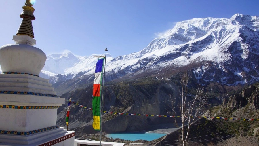
Gangapurna Lake above Manang, a common acclimatisation walk on Day 5.
Day 8 starts in the dark from High Camp and ends at Muktinath, then a jeep takes you down to Jomsom in the Kali Gandaki. It is covered on its own below.
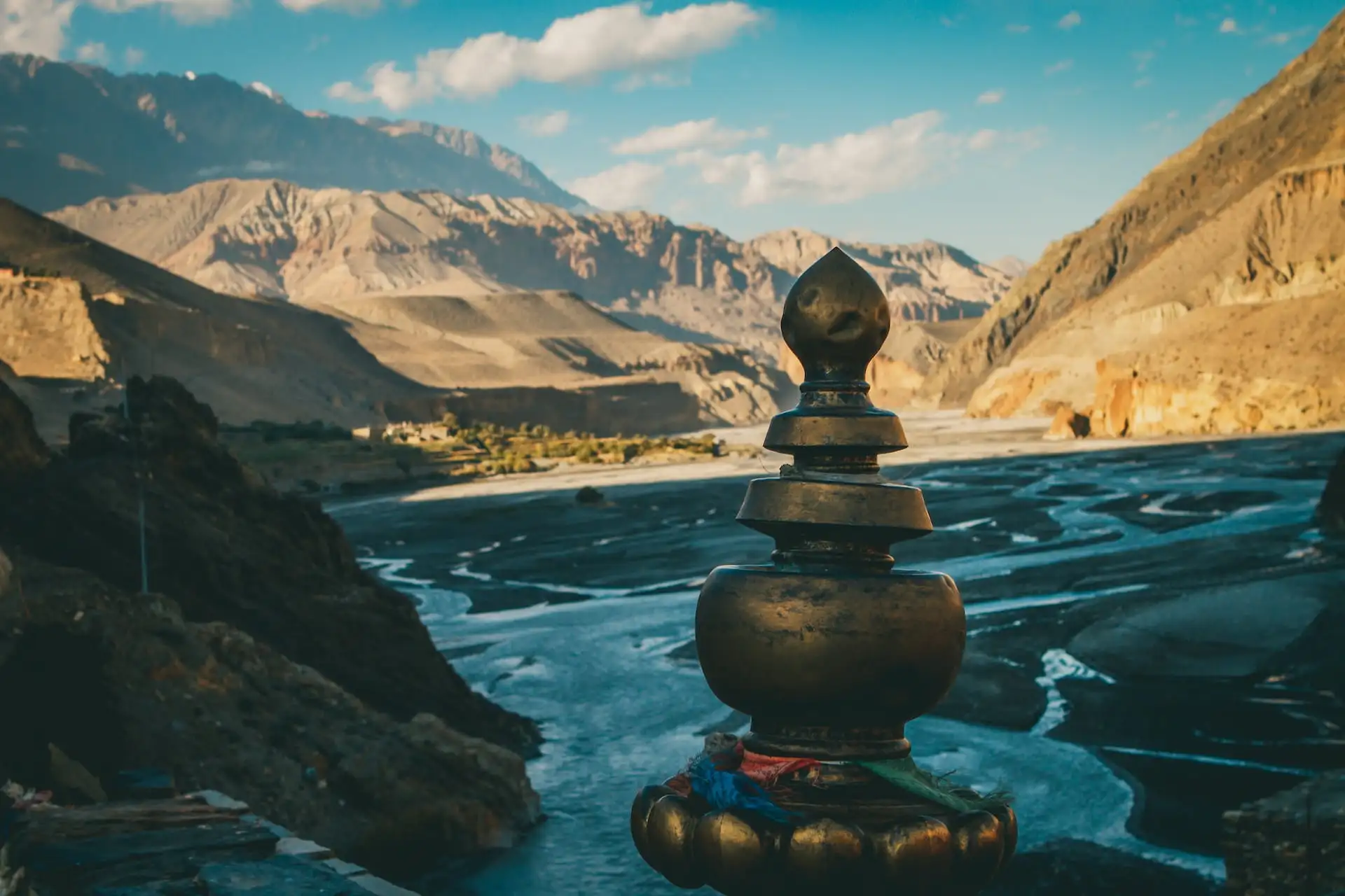
Kagbeni in the Kali Gandaki, on the way down from Muktinath to Jomsom.
Annapurna Circuit Altitude and Elevation Profile
The Circuit climbs from 760M at Besisahar to 5,416M on Thorong La, then drops to 2,720M at Jomsom. On the walking days you gain 3,565M and lose 2,533M, and almost half of that loss comes on the single crossing day.
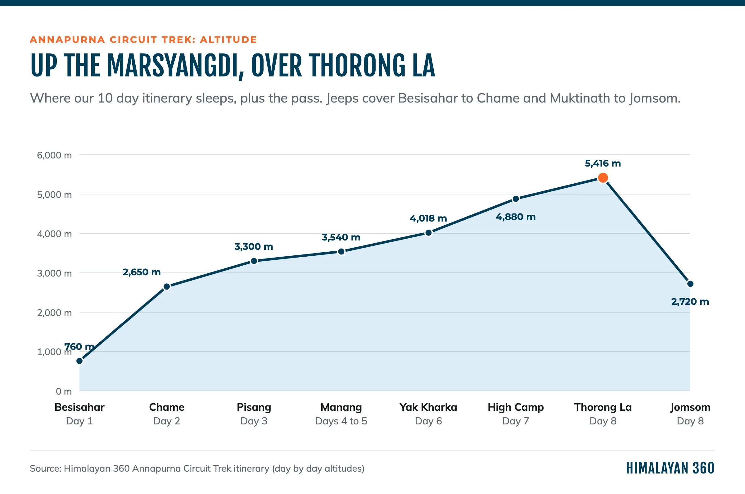
Where our 10-day itinerary sleeps, plus the pass.
Four nights are spent above 3,500M: two at Manang, one at Yak Kharka (4,018M) and one at Thorung High Camp (4,880M). That last night is the highest you sleep anywhere on the trek, and it is reached by the biggest single gain in sleeping altitude, which is why the altitude section focuses on it.
Thorong La Pass: The Crossing Day
Thorong La is 5,416M (17,769FT), the highest point of the Annapurna Circuit. On our itinerary it is crossed on Day 8: 535M up from High Camp, then 1,747M down to Muktinath, 14KM and about 9 hours of walking.
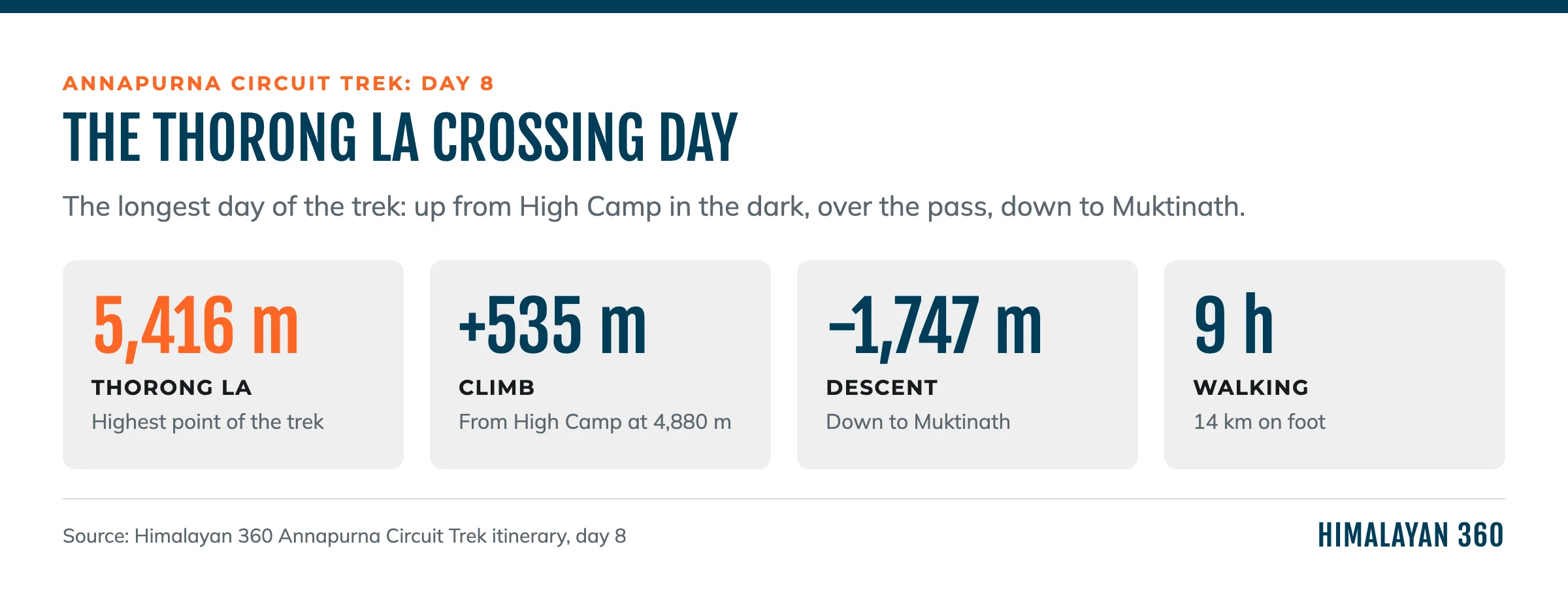
Day 8 of our itinerary.
- The start. You leave High Camp before dawn, with a headlamp, to cross before the wind picks up in the late morning.
- The climb. A steady path over moraine, with false tops. At this altitude the pace is slow for everyone.
- The top. Prayer flags, a teashop in season and wide views on both sides. Most groups stay a few minutes, not longer.
- The descent. The hard part for the knees: a long, steep drop on loose ground to Muktinath. Trekking poles help most here.
Some groups sleep at Thorong Phedi, below High Camp, which makes Day 7 easier and Day 8 longer. Your guide will decide with you, based on how you are at Yak Kharka. If the weather turns or someone shows signs of altitude sickness, the right decision is to wait or go down. The pass will still be there.
How Hard Is the Annapurna Circuit Trek?
Challenging, because of the altitude rather than the terrain. The trail is a good path for most of its length and needs no climbing skill in spring or autumn. What makes it hard is sleeping at 4,880M and crossing 5,416M the next morning.
Three things decide how the trek feels:
- The altitude after Manang. Yak Kharka, High Camp and the pass come one after another.
- The crossing day. About 9 hours, starting in the cold and finishing with a long descent.
- Cold. Nights above Manang are below freezing in the main seasons and the rooms are unheated.
Can a Beginner Do the Annapurna Circuit?
A fit beginner can, with training and a guide. It is a step up from Annapurna Base Camp, which tops out at 4,130M. If this is your first trek and you are unsure, start with ABC or Mardi Himal. If you go for the Circuit, train for 8 weeks on hills and stairs with a loaded pack, and treat the Manang rest day as fixed.
Annapurna Circuit Permits in 2026
You need the Annapurna Conservation Area Permit (ACAP) and a TIMS card. Adding the Nar Phu valley also needs a restricted area permit, which only a registered agency can file.
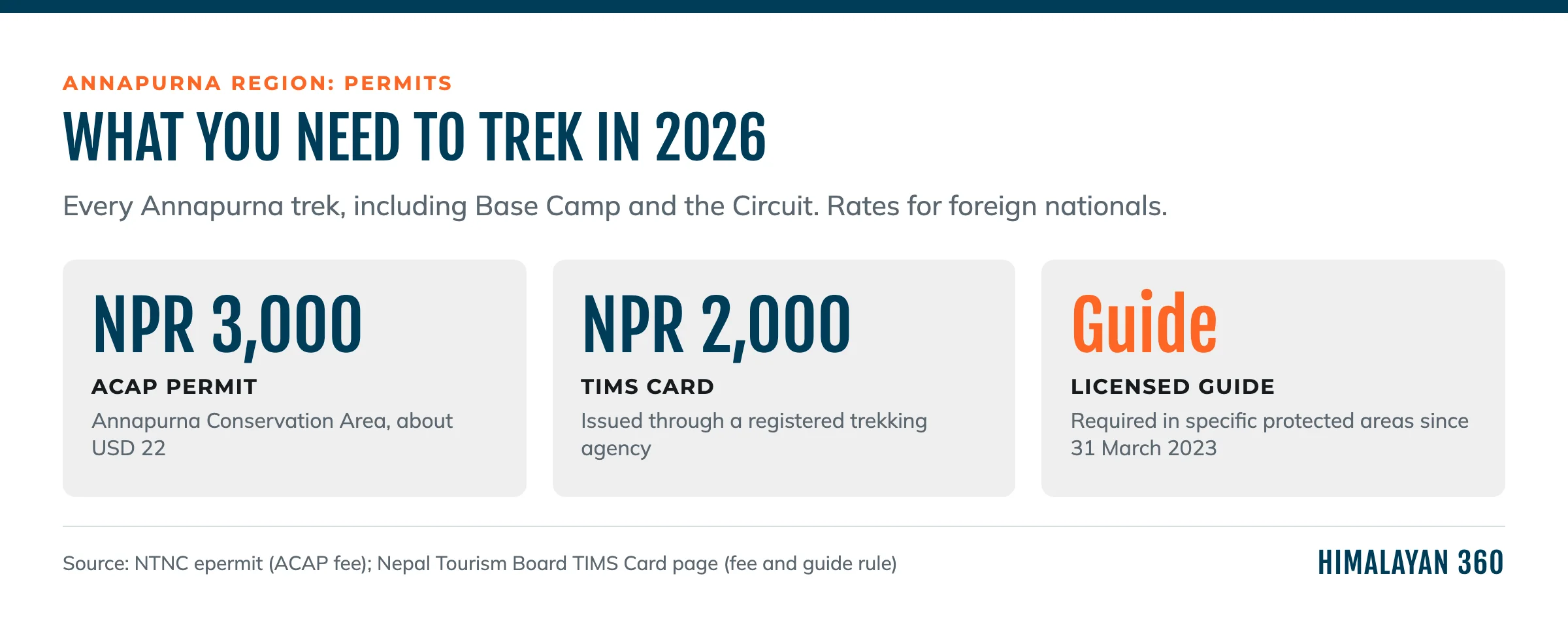
What you need for any Annapurna trek in 2026.
| Permit | Foreign nationals | SAARC nationals | Issued by |
|---|
| ACAP | NPR 3,000 (about USD 22) | NPR 1,000 | National Trust for Nature Conservation |
| TIMS card | NPR 2,000 | NPR 1,000 | Nepal Tourism Board, through a registered agency |
The ACAP fee is set by the National Trust for Nature Conservation. The TIMS fee and the agency rule are on the Nepal Tourism Board TIMS page. Permits are checked at the ACAP posts along the trail. ACAP, TIMS and the local government fees are all included in our package.
Do You Need a Guide for the Annapurna Circuit?
Yes. A licensed guide has been required since 31 March 2023. The Nepal Tourism Board's revised TIMS provision says that "specific Protected Areas of Nepal need trekker to be accompanied by licensed trekking guide and carry a trekking agency issued TIMS Card". Its Annapurna list starts with the Annapurna Circuit Trek, and also names Nar Phu, the Tilicho Pass trek, the Poon Hill-ABC trek, Khopra and Mardi Himal.
You can still trek the Circuit solo, just you and a guide. What you can no longer do is buy a TIMS card yourself and walk it alone. Many blogs from before 2023 still describe independent trekking on the Circuit. They are out of date.
On this trek a guide matters most in the two days before the pass: judging whether you are ready to sleep at High Camp, choosing the start time on Day 8, and turning the group round if the weather or someone's health says so. A porter is optional and not included in our package; we can add one.
How Much Does the Annapurna Circuit Trek Cost?
Our 10-day Annapurna Circuit trek is USD 599 to 790 per person, depending on the size of your group.
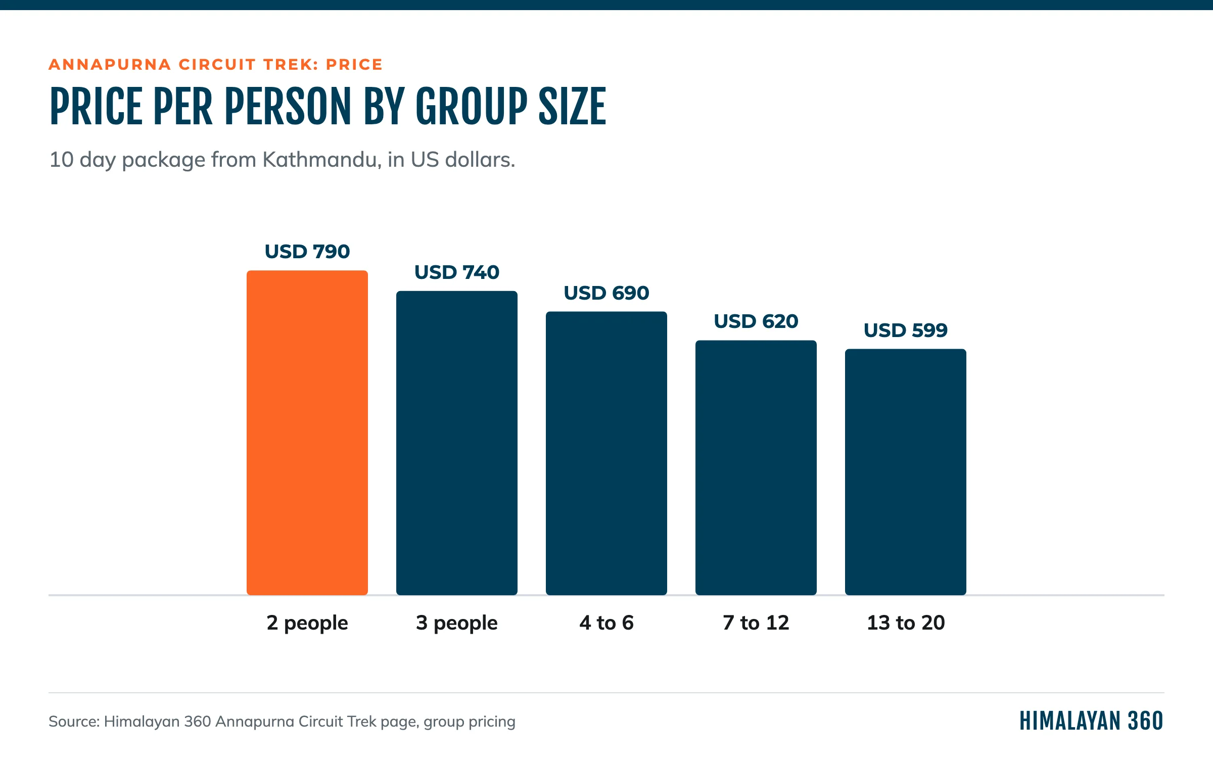
Price per person from Kathmandu, by group size.
Included: the bus to Besisahar, the jeep to Chame, the jeep from Muktinath to Jomsom, the bus to Pokhara and the tourist bus to Kathmandu, 1 night each in 3-star hotels in Kathmandu and Pokhara, 8 nights in teahouses, 9 breakfasts, 9 lunches and 9 dinners, a licensed guide, ACAP, TIMS and local government fees, and taxes.
Not included: travel insurance (compulsory, and it must cover helicopter rescue at altitude), a porter, flights, the Nepal visa, extra nights, drinks, hot showers, wifi, charging and tips. Food and drink prices rise above Manang, where everything is carried in. Take enough Nepali rupees from Kathmandu or Pokhara for the trek and do not rely on cash machines in the valley.
Full prices and dates are on the Annapurna Circuit Trek page.
Best Time to Trek the Annapurna Circuit
October and November are the best months, then March to May. Those are the months on our trip page, and they give the best chance of a clear, open pass.
Autumn: September to November
Autumn has the clearest skies and the most reliable crossing. It is also the busiest season, so lodges at Manang and High Camp fill up. Late September can still bring monsoon storms, as it did in 2026.
Spring: March to May
Spring is the second season. Early March can still have snow on the pass. April and May are warmer, with more haze in the lower valleys.
Annapurna Circuit Weather in Winter and Monsoon
Winter, December to February, brings snow that can close Thorong La for days at a time, and very cold nights at High Camp. Monsoon, June to August, is the season for landslides on both access roads, though the upper Manang valley sits in the rain shadow and stays drier than the south side of the range. Neither season is impossible, but both need spare days and a guide who knows when to wait.
The Annapurna Circuit Road: Is It Still Worth Doing?
Yes, if you drive the low ground and walk the high middle. A road now runs up the Marsyangdi from Besisahar towards Manang and down the Kali Gandaki from Muktinath. Walking those sections means walking beside jeeps and dust. Driving them, as our itinerary does, keeps the walking for the part that is still a trail: Chame to Thorong La to Muktinath.
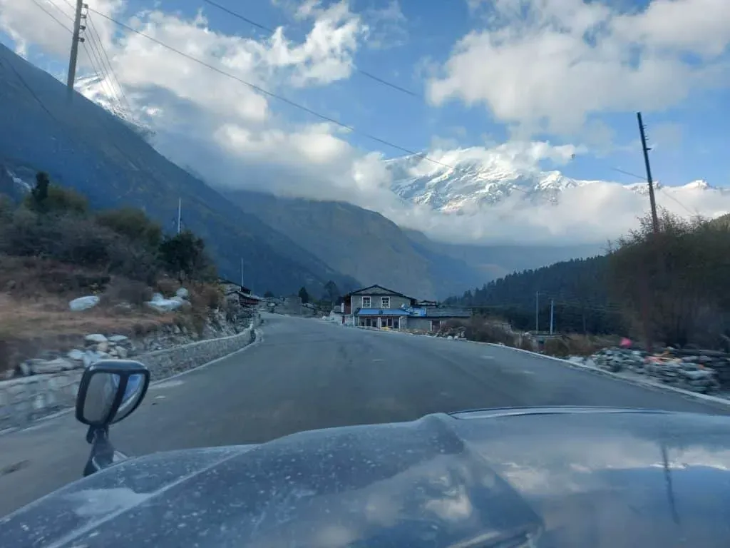
The road from Jomsom up to Muktinath, on the west side of the pass.
The road is also why the Circuit is shorter now than its reputation. Itineraries that once took three weeks fit into ten days without cutting the pass or the acclimatisation. The flip side is landslides: a closed road at either end can cost a day, which is why we keep a contingency day in mind for every departure.
Tea Houses on the Annapurna Circuit
You sleep in tea houses every night of the trek: lodges with twin rooms, shared bathrooms and a heated dining room. The Circuit is well supplied with lodges, and Manang has the best-stocked ones on the route.
- Food. Dal bhat everywhere, with refills, plus noodles, pasta, potatoes, eggs and Tibetan bread. Manang has bakeries.
- Rooms. Unheated above the lower valley. At High Camp they are basic and cold.
- Water. Boiled water from the lodges or purification tablets. Plastic bottles are discouraged in the conservation area.
- Hot showers, wifi and charging. Paid extras that get dearer and less reliable higher up. Bring a power bank.
- Mobile signal. Available in Manang and the bigger villages, patchy near the pass.
Tilicho Lake, Tatopani and Muktinath: Side Trips
The three common additions to the Circuit are Tilicho Lake from Manang, Muktinath temple after the pass, and the Tatopani hot springs below Jomsom.
- Tilicho Lake. A high glacial lake reached from Manang. The Nepal Tourism Board lists the Tilicho route among those needing a licensed guide. It adds days and altitude to the itinerary, so ask us before you plan it. Its status was not confirmed in our last trail update.
- Muktinath. A temple sacred to both Hindus and Buddhists, just below the pass on the west side. You walk through it on Day 8.
- Tatopani. Natural hot springs in the lower Kali Gandaki, on the way to Ghorepani for itineraries that walk out to Poon Hill.
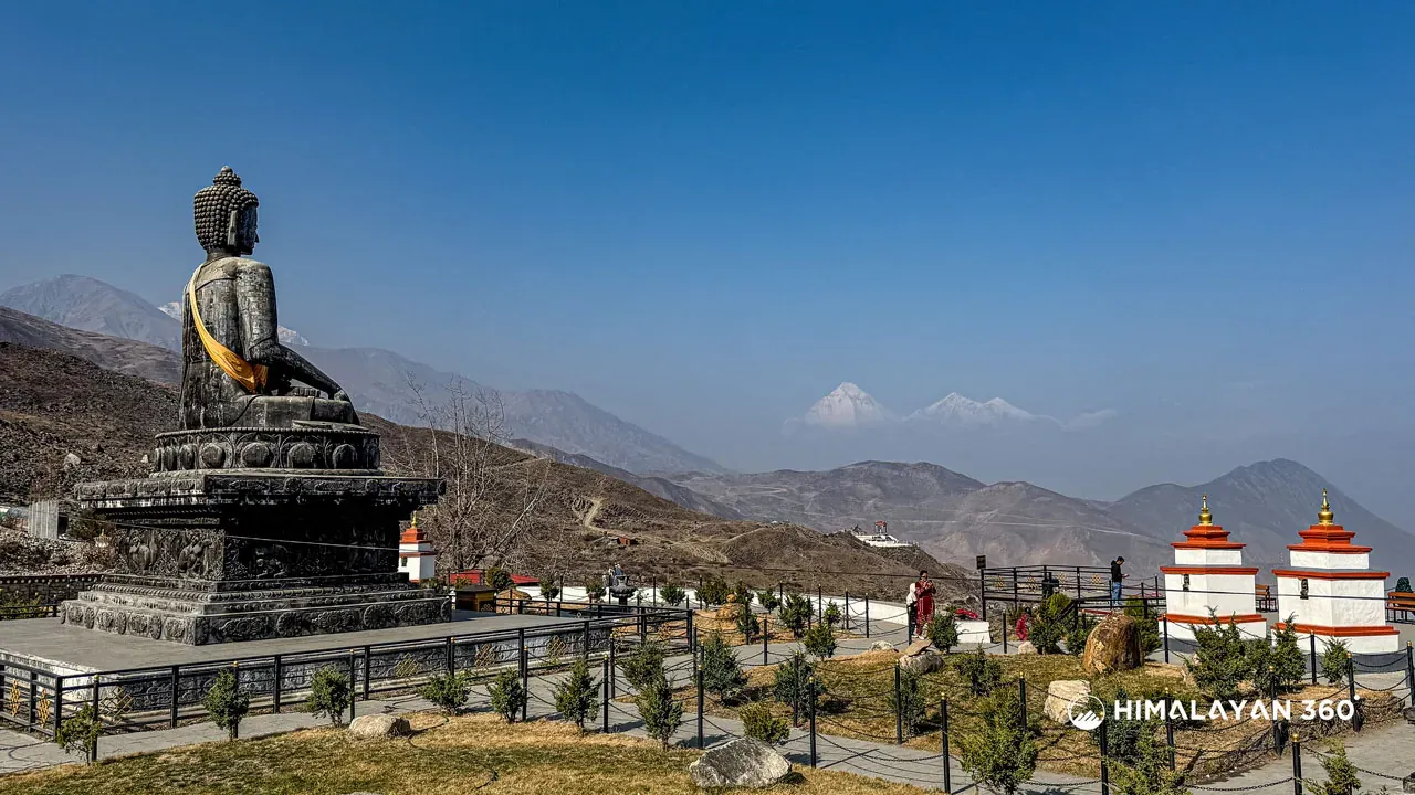
Muktinath, the first stop after the pass.
Muktinath and Kagbeni are also the gateway to Upper Mustang, a separate restricted area covered in our Upper Mustang trek guide. If you only want Muktinath without the pass, our Muktinath Jeep Tour goes there by road.
Altitude Sickness and Acclimatisation in Manang
The night to watch is Day 7, Yak Kharka (4,018M) to High Camp (4,880M). That is 862M of sleeping gain in one day, well above the usual guideline of 300 to 500M a day above 3,000M. It is the shape of almost every Circuit itinerary, because High Camp is where you need to be to cross the pass in the morning.
Two things soften it:
- The Manang day. Climb high on Day 5 and sleep low. Do not skip it.
- Thorong Phedi. Sleeping at Phedi instead of High Camp lowers that night, at the cost of a longer Day 8.
If symptoms get worse at Yak Kharka or High Camp, go down. Our full guide to preventing altitude sickness explains what to watch for.
What to Pack for the Annapurna Circuit
Pack for warm lower valleys and a freezing night at 4,880M. Our package includes a guide, not a porter, so pack for your own back or add a porter.
Packing Checklist
- Broken-in trekking boots and camp shoes
- Trekking poles for the descent from Thorong La
- A warm down jacket, a fleece and a windproof shell
- Waterproof trousers
- Thermal base layers
- A sleeping bag rated to about minus 15°C, or rent one in Kathmandu or Pokhara
- Warm hat, buff, insulated gloves and sunglasses
- Sunscreen and lip balm
- Water bottles and purification tablets
- A headlamp with spare batteries for the pre-dawn start
- A first aid kit and blister plasters
- Cash in Nepali rupees
- A power bank
Annapurna Circuit vs Annapurna Base Camp
The Circuit is higher, longer and more varied. Annapurna Base Camp is shorter and gentler. The Circuit crosses a 5,416M pass and changes landscape completely, from green Marsyangdi valley to the dry, Tibetan-style villages around Manang and Muktinath. ABC goes up one valley into the Sanctuary at 4,130M and back.
Choose the Circuit if you want a crossing, variety and a bigger altitude goal. Choose Annapurna Base Camp if it is your first trek, if you have less than ten days or if you want the mountains around you rather than across a valley.
Trek the Annapurna Circuit With Us
Our Annapurna Circuit Trek is the 10-day itinerary in this guide, with a licensed guide, permits, teahouses and transport included. For a quieter, longer version, our Nar Phu Valley Trek adds the restricted Nar and Phu valleys before Thorong La. Every trek in the Annapurna region we run is on one page.
Ask us about dates, and we will tell you what the pass and the roads look like in your week before you book.
 Trek
 By air
 Pilgrimage
 Festivals
 Wildlife
 Luxury
 Yoga
 Food
 Heritage
